
Maps
-
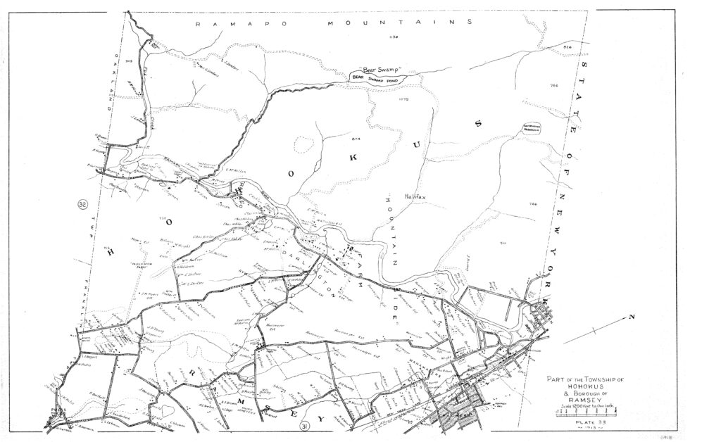
1913 Map of Hohokus Township -
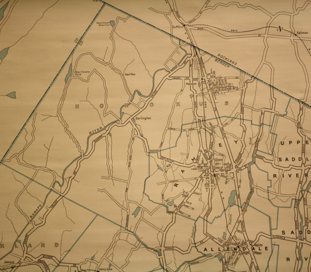
Hohokus Township in 1926. -
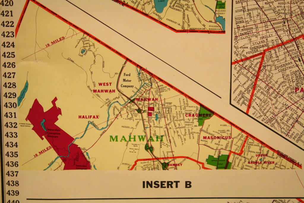
A 1970 Map of Mahwah.
Mahwah Map Collection
| Date | Map Area | Title / Map Description |
| 1659 | The Eastern seaboard of the United States | Presents a map of the Dutch colonies in the New World. |
| 1710 | Schuyler Patent | This is a map of the Schuyler Patent with an extensive description of the land boundaries of the Patent. The Schuyler Tract approximated the boundaries of what became Bergen County which is 42,500 acres. This is the William Bond map of the Ramopock Tract. |
| 1767 & 1768 | Ramopock Tract | This is a very old map of the “A Map of Ramopock Tract 1868”. Ramopock Tract showing large acreage and owner’s names. Alexander & Morriss made this map for the Properties of East Jersey in 1768 to show the portions of the Ramopock tract that had been sold prior to 1767. |
| 1767 & 1768 | Ramopock Tract | This is a very old map of the Ramapock Tract showing large acreage and owner’s names. This map is based on the Alexander & Morriss Survey map in the map room of the Bergen County Court House – The Bergen County Historical Society – C.K. Tholl – Delineator 1963 |
| 1861 | Bergen & Passaic Counties | Map of Bergen & Passaic Counties, NJ from actual surveys by G.M. Hopkins. Shows the towns of HoHoKus, Franklin, Washington, Harrington, New Barbadoes, Lodi, Union, Saddle River and Hackensack. A Colored Map. |
| 1861 | HoHoKus, Mahwah, Allendale and Ramsey | An enlarged section of the above map showing the townships of HoHoKus, Mahwah, Allendale and Ramsey. Includes a map of the Paterson Business District with a list of lawyers, physicians, editors and merchants. |
| 1861 | Darlington, Mahwah to Suffern, east to Ramsey | Plate 33 from the 1913 Atlas of Bergen County, Volume 2. Part of the Township of HohoKus and Borough of Ramsey. The Darlington hamlet of Mahwah, Mahwah to Sufferm and east to the Borough of Ramsey are shown. |
| 1876 | Bergen County NJ | Atlas of Bergen County New Jersey. Presents detailed maps of all of the towns, villages, boroughs, sections located within Bergen County. Shows the names of each landowner. Historical, Illustrated, Geological & Topographical. Many illustrations of large & important homes & factories. |
| 1876 | Passaic County NJ | Atlas of Passaic County New Jersey. Presents detailed maps of all of the towns, villages, boroughs, sections located within Passaic County. Shows the names of each landowner. Historical, Illustrated, Geological & Topographical. Many illustrations of large & important homes & factories. |
| 1876 | Rockland County NY | Atlas of Rockland County New York. Presents detailed maps of all of the towns, villages, boroughs, sections located within Rockland County. Shows the names of each landowner. Historical, Illustrated, Geological & Topographical. Many illustrations of large & important homes & factories. |
| 1876 | Rockland County NY | Atlas of Rockland County New York. Presents detailed maps of all of the towns, villages, boroughs, sections located within Rockland County. Shows the names of each landowner. Historical, Illustrated, Geological & Topographical. Many illustrations of large & important homes & factories. |
| 1876 | Ramapo Township New York State | Map of Ramapo Township with all parcels of land including the landowner’s names. Stamped on back “Shatemuc Chapter Daughter of the American Revolution” 3 copies |
| 1876 | Orangetown New York State | Map of Orangetown, NY with all parcels of land including the landowner’s names |
| 1889 | The entire State of New Jersey | Presents maps for all of the counties of the entire state of New Jersey (Topographic). All of the maps are in fragile condition. |
| 1893 | Ramapo NY & surrounding towns | Presents the Ramapo Quadrangle – New Jersey – with dots representing structures – homes, schools, stores, etc. Major roads. rivers, ponds, farmland, swamps are shown. Hillsdale to Spring Valley NY – 7.5 Minute Series (Topographic). A colored map. |
| 1900s | HoHoKus Township | This is a map of the Township of Hohokus. It presents the following towns: Hohokus, Mahwah, Ramsey, and Allendale. |
| 1901 reprinted 1938 | West Point NY & surrounding towns | Presents the West Point Quadrangle – Grid Zone A – New York. Corps of Engineers U.S. Army with dots representing structures – homes, schools, stores, etc. Major roads. rivers, ponds, farmland, swamps are shown. 7.5 Minute Series (Topographic) 19 copies of this colored map |
| 1902 reprinted 1912 | Schunemunk Mountain Area & surrounding towns | Presents the Schunemunk Mountain Quadrangle – New York – with dots representing structures – homes, schools, stores, etc. Major roads. rivers, ponds, farmland, swamps are shown. 7.5 Minute Series (Topographic) A colored map. |
| 1902 reprinted 1914 | Tarrytown NY & surrounding towns | Presents the Tarrytown Quadrangle – New York – with dots representing structures – homes, schools, stores, etc. Major roads. rivers, ponds, farmland, swamps are shown. 7.5 Minute Series (Topographic) A colored map. |
| 1904 | Ramsey | Map of Ramsey, Bergen County New Jersey showing the Rural Free Delivery – RFD – routes in Ramsey, NJ |
| 1910 | Ramapo and Suffern NY & surrounding towns | Presents the Ramapo Quadrangle – New York – with dots representing structures – homes, schools, stores, etc. Major roads. rivers, ponds, farmland, swamps are shown. 7.5 Minute Series (Topographic) A colored map. Suffern NY to Waldwick NJ |
| 1910 reprinted 1942 | Greenwood Lake and surrounding towns | Presents the Greenwood Lake Quadrangle – NJ – NY with dots representing structures – homes, schools, stores, etc. Major roads. rivers, ponds, farmland, swamps are shown. A section of the Ramapo Mountains is included. 7.5 Minute Series (Topographic) Separate Greenwood Lake map. |
| 1912 | Hudson Valley | Map details the roads and neighborhoods of the Hudson Valley from NYC, Delaware and Ulster counties. Further information is missing from the map. |
| 1915 | Township of Mahwah | This is an atlas of tax maps for the Mahwah section of the Township of Hohokus. It presents all of the parcels of land within Mahwah, their size in acres and the name of the landowner. |
| 1915 | Ho-Ho-Kus Township which Mahwah was a part of prior to 1944 | This is an atlas of tax maps for the Mahwah section of the Township of Hohokus. It presents all of the parcels of land within Mahwah, their size in acres and the name of the landowner. |
| 1915 Revised 1935 | Borough of Ramsey | This is an atlas of tax maps for the Boroughs of Ridgewood, Washington, Midland Park, Upper Saddle River, Glen Rock and Ho-Ho-Kus. It presents all of the parcels of land within Ramsey, their size in acres and the name of the landowner. |
| 1916 | Borough of Ramsey | This is an atlas of tax maps for the Borough of Ramsey. It presents all of the parcels of land within Ramsey, their size in acres and the name of the landowner. |
| 1925 | Map of Cragmere | Map of the Cragmere section in the Ramapos in Mahwah, N.J. Property of the Mahwah Company Van Fossen – Leo Bugg Realty Company, New York City Sales Agents. |
| 1925 rev 1934 & 1951 | Developed areas of Mahwah | Sanborn Map Company Insurance Map of Mahwah. For Water facilities and Fire Department shown structural components of homes and buildings – colored. |
| 1925 rev 1942 & 1951 | Developed areas of Mahwah | Sanborn Map Company Insurance Map of Mahwah. For Water facilities and Fire Department shown structural components of homes and buildings – colored. |
| 1926 | Erie Railroad | Map of Erie Railroad published in connection with the “Road To Summer” Land. Shows the Erie Railroad lines between New York and eastern Pennsylvania and southern New York State – two sided |
| 1928 | Village of Suffern New York State | Building Zone Map of the Village of Suffern, New York State |
| 1937 | Borough of Paramus | This is an atlas of tax maps for the Borough of Paramus. It presents all of the parcels of land within Paramus, their size in acres and the name of the landowner. |
| 1938 | Ramapo and Suffern NY & surrounding towns | Presents the Ramapo Quadrangle – New York – with dots representing structures – homes, schools, stores, etc. Major roads. rivers, ponds, farmland, swamps are shown. 7.5 Minute Series (Topographic) A colored map. |
| 1940 | Mahwah & Ramsey NJ & surrounding towns | Presents the Ramsey Quadrangle – New Jersey – with dots representing structures – homes, schools, stores, etc. Major roads. rivers, ponds, farmland, swamps are shown. 7.5 Minute Series (Topographic) A colored map. Suffern NY to Wyckoff NJ |
| 1945 | Township of Mahwah | This is an atlas of revised tax maps for the Township of Mahwah. This is an revised tax map of the 1915 Tax map (see above). It presents all of the parcels of land within Mahwah, their size in acres and the name of the landowner. Bound with cover. |
| 1945 | Park Ridge NJ & surrounding towns | Presents the Park Ridge Quadrangle – New Jersey – with dots representing structures – homes, schools, stores, etc. Major roads. rivers, ponds, farmland, swamps are shown. Hillsdale to Spring Valley NY – 7.5 Minute Series (Topographic) A colored map. |
| 1955 | Major sections of Mahwah, Ramsey & surrounding towns | Presents the Ramsey Quadrangle – New Jersey – New York with dots representing structures – homes, schools, stores, etc. Major roads. rivers, ponds, farmland, swamps are shown. A section of the Ramapo Mountains is included. 7.5 Minute Series (Topographic) |
| 1955 | Major sections of Mahwah, Ramsey & surrounding towns | Soil Survey of Bergen County – the Ramsey Quadrangle and the Park Ridge Quadrangle. Complied by an 1986 aerial photograph |
| 1955 | Monroe NY and surrounding towns | Presents the Theills Quadrangle – NJ – NY with dots representing structures – homes, schools, stores, etc. Major roads. rivers, ponds, farmland, swamps are shown. A section of the Ramapo Mountains is included. 7.5 Minute Series (Topographic) |
| 1955 | Monroe NY and surrounding towns | Presents the Monroe Quadrangle – NJ – NY with dots representing structures – homes, schools, stores, etc. Major roads. rivers, ponds, farmland, swamps are shown. A section of the Ramapo Mountains is included. 7.5 Minute Series (Topographic) |
| 1950 through 1957 | Township of Mahwah | This is an atlas of revised tax maps for the Township of Mahwah. This is an revised tax map of the 1945 Tax map (see above). It presents all of the parcels of land within Mahwah, their size in acres and the name of the landowner. |
| 1950 through 1965 | Township of Mahwah | This is an atlas of revised tax maps for the Township of Mahwah. This is an revised tax map of the 1950 Tax map (see above). It presents all of the parcels of land within Mahwah, their size in acres and the name of the landowner. |
| 1950 through 1967 | Township of Mahwah | This is an atlas of revised tax maps for the Township of Mahwah. This is an revised tax map of the 1950 Tax map (see above). It presents all of the parcels of land within Mahwah, their size in acres and the name of the landowner. |
| 1969 | The entire State of California | Presents many maps of the entire State of California . Hard cover – bound maps – maps fold out. Part 2 of 2 parts. |
| 1950 through 1973 | Township of Mahwah | This is an atlas of the revised tax maps for the Township of Mahwah. This is an revised tax map of the 1950 Tax map (see above). It presents all of the parcels of land within Mahwah, their size in acres and the name of the landowner. |
| 1950 through 1978 | Township of Mahwah | This is an atlas of the revised tax maps for the Township of Mahwah. This is an revised tax map of the 1950 Tax map (see above). It presents all of the parcels of land within Mahwah, their size in acres and the name of the landowner. |
| 1950 through 1983 | Township of Mahwah | This is an atlas of revised tax maps for the Township of Mahwah. This is an revised tax map of the 1950 Tax map (see above). It presents all of the parcels of land within Mahwah, their size in acres and the name of the landowner. |
| 1995 | Mahwah & Ramsey NJ & surrounding towns | Presents the Ramsey Quadrangle – New Jersey – with dots representing structures – homes, schools, stores, etc. Major roads. rivers, ponds, farmland, swamps are shown. 7.5 Minute Series (Topographic) A colored map. |
| 1995 | Park Ridge NJ & surrounding towns | Presents the Park Ridge Quadrangle – New Jersey – with dots representing structures – homes, schools, stores, etc. Major roads. rivers, ponds, farmland, swamps are shown. 7.5 Minute Series (Topographic) A colored map. |
| 1950 through 2007 | Township of Mahwah | This is an atlas of revised tax maps for the Township of Mahwah. This is an revised tax map of the 1950 Tax map (see above). It presents all of the parcels of land within Mahwah, their size in acres and the name of the landowner. |
| 2012 | Mahwah | Digital print of the Township of Mahwah, Bergen County New Jersey |
| 1990s | Mahwah & Oakland | Ramapo Mountains – Mahwah & Oakland Parks. Hand drawn map details the ownsership of the parks – Protected / Unprotected / Privately owned west of the Ramapo River. Undated, but prior to I-287 construction – circa 1990. Colored. |
| Untitled & Undated | Suffern Area | An untitled and undated map showing the following areas: Mahwah, Bellgrove, Suffern, Sloatsburg, Long Pond and the Ramapo Mountains. |