
Cemetery of the Old Ramapo Lutheran Church, Moffatt Road, Mahwah
By Charles Anderson, The Old Station Timetable, February 1980 and April 1980.
The congregation of the Ramapo Lutheran Church chose a sandy hill west of the church on what is now Moffatt Road for its burial ground. It overlooked the valley up to the Ramapo hills. Never did they envision the bustle of a crowded highway, nor the encroachment that today puts the hill in danger of gradually sliding, grave by grave, onto the border of Route 17.
It is a neglected plot of ground in imminent danger of total destruction as land values ‘increase and this’ irreplaceable part of Mahwah’s historic past becomes a burden on its present owner.
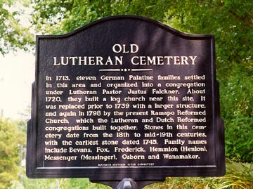
The first log church of the early German Lutheran inhabitants was built on Island Road near Moffatt Road in 1720. It was abandoned in 1789, but burials continued into the middle 1800’s. The early group was probably partly absorbed by the Dutch Reformed Church which was formed in 1785. That building was built in 1795.
There are probably many unmarked graves from that early time. Certainly there are many that are marked by a simple field stone without inscriptions. Others bear only initials chiseled in by some survivor, their family names a matter of guesswork. Among these are probably members of the families of the oldest settlers of the valley, men and women who came north from the Paramus and Hackensack area and west from settlements along the Hudson. The earliest legible date is 1758, with about 45 other stones in the 1700’s. After 1867, the cemetery seems to have been abandoned.
Derick Wanamaker was an original lessee in the Ramapo tract in 1740. A few legible stones may be his descendants, M., 1729; Richard, 1750; James, 1752. A young boy, Josiah, buried in 1839 is noted as the tenth son of John (no daughters are mentioned). Henry and Peter W.-10t #155 on the Ramapo Tract map had Airmount Road on its northern border. Susannah W.-#139 had land between Island Road the the railroad tracks. Derick’s family had been a potent force in the development of this area.
The Hemions too have imprinted their name on the community, since Stephen Hemion (Hemmion) on the stone selected lot #150. He was buried here with his wife, Ellen, in 1791 with many of his descendants nearby. The family name was variously spelled Hemmion and Hemion, each different from the spelling on the early 1787 survey.
David Fox 1755-1800 and his wife, Catherine Hemion – 1831 farmed lot #120 on the east side Frederick (lot #72) which was east of the Ramapo River on both sides of the present state line. Their children and grandchildren lie with them, the last being David D. Fox 1793-1869. Some of the Fox family still living in the area can probably trace their ancestry to this early settler, whose grave lies uncared for in the little cemetery.
Henry Frederick, 1729-1790, and several of his children are nearby.
John Bush, who died in 1812, could have been a son of Samuel Bush, who owned lot #96A south of the Frederick land.
Michael Fisher owned #154, including Hilltop Rd. There is a stone listing Mikel Fisher, 1722-1802, with two Fisher women, Mary, who died at 89 in 1812, and Catrin (Fishar), 1777-1793. A few years ago, Fanny Fisher Bartold, who lived in the Fardale section, died in her 100th year. She was raised in the Airmont area of Ramsey, which includes the old Fisher tract.
Adjoining the Fisher land is that of Conradt Brown, -1793 and Mary, his wife, 1777-1793. On the stone, the name is spelled Broun and Conrad loses its T.
One small stone reminds us that “Here lyeth the body of John Suffern, son of John and Mary Suffern of New Antrim, 11 mo., 1777.” On Darlington Ave., west of Grove St., lot #132 is in the name of Mary Ramsey. The young couple settled in Suffern (New Antrim) in 1773 and probably came to the nearest church for services. John Ramsey was one of the founders of the Dutch Reformed Church, and there he and many of his family are buried. There were 11 children just a short distance away from the boy who might have been his firstborn.
The Messenger family settled lot #24. This family too varied the spell ing of its name. Coonrad Mausenger, -1804, Nicholas Maysinger, 1760?-1804, Susannah, the wife of Nicholas Messenger, -1843, and Michael, 1774-1852 and Mary, 1777-1859. Lot #24 was taken by Henry Messenger. It was he who originally gave the church land to the Lutheran Church. Although not marked, he MUST be buried there.
There are many Carlough graves, and since a Carlough was an owner of a lot in the tract, here could be another of our very earliest residents. Some of the stones leave us wondering. Was Molle Hunter really Molly? Who was the Asler (Esler) family who was buried between 1774 and l798? What early names are hidden in the initialed and unmarked stones?
And what of Elias Fall; who died Jan. 31, 1771 at the age of 88? Who could the man have been, a strange name among the German and Dutch families of the early congregation?
This forgotten burial ground is as important in the history of Mahwah as Lorn Hill to Plymouth or Trinity Churchyard to New York. There must be some way that it can be saved for the future. It’s almost too late!